AI Ocean Forecasting: From Deep-Sea Data to Mesoscale Eddy Prediction
News Details
Ocean data is growing fast. AUVs, ROVs, buoys, satellites, seabed sensors, and research vessels now collect large amounts of marine information every day. However, raw data alone is not enough. Teams also need tools that can read patterns, forecast changes, and support better decisions.
This is where AI ocean forecasting becomes useful. By using a deep-sea foundation model, marine teams can turn complex data into clearer insight. As a result, ocean eddy prediction, route planning, survey timing, and long-term marine monitoring can become more accurate and efficient.
PALEGIX provides advanced underwater systems and marine AI solutions for civil ocean applications, including oceanographic research, seabed mapping, marine environmental monitoring, and underwater data collection.
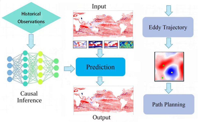
What Is an AI Ocean Forecasting Model?
An AI ocean forecasting model is a digital system that learns from ocean data. It can study changes in temperature, salinity, current, pressure, depth, and other marine factors. Then, it can help forecast how ocean conditions may change over time.
Unlike basic models, marine AI can process many data sources at once. For example, it can combine deep-sea sensor data, satellite data, historical survey records, and real-time field data. Because of this, it can find links that may be hard to see with manual analysis.
In practical use, AI ocean forecasting can help teams plan surveys, improve data collection routes, and understand ocean changes with more confidence.
Why Deep-Sea Data Needs Smarter Tools
Deep-sea data is often hard to collect, hard to clean, and hard to compare. Conditions can change by depth, season, location, and seafloor shape. Also, data may come from different tools and formats.
A deep-sea foundation model helps solve this problem. It is designed to learn from large marine datasets and support many kinds of ocean tasks. Instead of building a separate model for every project, teams can use one strong base model and adapt it to each survey goal.
For example, a research team may use it for temperature trend analysis. An offshore energy team may use it for current forecasting near underwater structures. A survey team may use it to plan better routes for seabed mapping.
Therefore, a deep-sea foundation model can become a core tool for modern marine work.
Understanding Mesoscale Eddies
Mesoscale eddies are large rotating water movements in the ocean. They can last for weeks or months and may stretch across many kilometers. These eddies can move heat, salt, nutrients, and marine life through the water.
Because they affect ocean conditions, mesoscale eddies are important for oceanographic surveys. They can change current speed, water temperature, and water layers. In some cases, they may also affect how sensors collect and report data.
Ocean eddy prediction helps teams understand where these eddies may form, how they may move, and how they may change. With better forecasts, teams can plan field work with less uncertainty.
How Ocean Eddy Prediction Supports Marine Surveys
Ocean eddy prediction can support many civil marine tasks. First, it helps improve survey timing. If a team knows that an eddy may affect a survey area, they can adjust the schedule or route.
Second, it helps improve data quality. Eddy activity can influence temperature, salinity, and current readings. When teams understand these changes, they can better explain survey results.
Third, it can support long-term monitoring. By tracking eddy patterns over time, researchers can study how ocean systems change across seasons and years.
As a result, ocean eddy prediction is not only a research tool. It is also useful for marine engineering surveys, environmental studies, offshore wind site planning, and seabed data work.
From Raw Data to Useful Forecasts
An AI ocean forecasting model works best when the data workflow is clear. The process usually starts with data collection. AUVs, ROVs, buoys, and other systems collect data from the field.
Next, the data is cleaned and checked. This step is important because ocean data may include gaps, noise, or sensor drift. After that, the model studies the data and looks for patterns.
Then, the model can create forecasts, maps, or trend results. These outputs help users see where conditions may change and what may happen next.
Finally, teams can use the forecast to plan future missions. This creates a better loop: collect data, learn from it, forecast changes, and improve the next survey.
Key Benefits of Marine AI
Marine AI can help B2B users work faster and make better use of their data. It can also reduce repeated manual work.
Key benefits include:
Faster analysis of large ocean datasets.
Better support for survey planning and route design.
Clearer understanding of currents, water layers, and eddy activity.
More useful forecasts for marine monitoring projects.
Easier use of long-term historical data.
Improved support for AUV and ROV mission planning.
Because of these benefits, marine AI is becoming an important part of ocean science and underwater engineering work.
Applications for PALEGIX AI Ocean Forecasting
PALEGIX AI ocean forecasting solutions can support a wide range of civil marine tasks.
For oceanographic research, they can help study water movement, eddy patterns, and deep-sea changes. For seabed mapping, they can support better mission planning by showing likely current and water condition changes. For offshore wind projects, they can help teams understand marine conditions around project sites.
In addition, AI forecasts can support coastal monitoring, deep-sea scientific research, underwater infrastructure inspection planning, and long-term marine data programs.
By linking underwater vehicles, sensors, and AI models, PALEGIX helps users build a more complete marine data workflow.
What Buyers Should Check Before Choosing a System
Before choosing an AI ocean forecasting model, buyers should define their main goal. Different projects may need different data inputs, forecast ranges, and output formats.
Important questions include:
What ocean data sources are available?
Is the focus on eddy prediction, current forecasting, temperature change, or full ocean condition analysis?
How often will new data be added?
What forecast range is needed?
Will the model support AUV or ROV mission planning?
What maps, charts, or reports are required?
How will the results be used by field teams?
With clear answers, PALEGIX can help match the right marine AI system to the project.
Why Integration Matters
AI forecasting is most useful when it connects with real field work. A model should not sit apart from the survey system. Instead, it should support data collection, mission planning, and result review.
For example, an AUV can collect deep-sea data during a survey. The data can then support model updates. After that, the AI forecast can help plan the next mission route. This makes each mission more informed than the last.
In this way, the AI ocean forecasting model becomes part of a full ocean data cycle. It helps teams move from simple data storage to active insight.
Build Smarter Ocean Forecasting With PALEGIX
AI ocean forecasting is helping marine teams understand the ocean in a clearer and faster way. With a deep-sea foundation model, ocean eddy prediction, and marine AI tools, users can turn deep-sea data into practical forecasts for research, monitoring, and survey planning.
PALEGIX supports advanced underwater systems and AI model solutions for civil marine applications. To learn more about the AI ocean forecasting model category, visit:
https://www.pelagix-tech.com/products/category/Al-Forecasting-Identification-Large-Model
To discuss your project needs with PALEGIX, contact the team here:


